Inpixon Hero Image Created with Sketch.

Inpixon RTLS

Real-Time Location Systems

Explore Inpixon's industry-leading RTLS products or read on to learn more about these components and how real-time location systems work

Request Consultation

What is a Real-Time Location System?

Real-time location systems (RTLS) enable you to digitally track the real-time location and movements of physical things throughout large indoor facilities. As a type of indoor positioning system, RTLS primarily leverage radio-frequency (RF) technologies like UWB, BLE and Chirp, as well as wireless devices, such as tracking tags and smartphones, alongside other integrated components, to continuously determine the position of people and objects in areas GPS is not able to reach. This delivers actionable location data that can be used to visualize the location of key personnel, assets, vital equipment and more on a live, indoor map or integrated into automated workflows and systems such as IoT-enabled safety applications, asset & supply chain management solutions and more.

It’s been estimated that GPS technology has created over $1.4 trillion dollars (RTI International) in value for U.S. private sector industries since it was made accessible in the 1980s. RTLS seek to unlock the same location-aware value that GPS has created in our outdoor world for indoor spaces and localized areas where GPS isn’t effective. A key foundation of digital innovation, digital twin technology, IoT, and Industry 4.0, real-time location systems are helping organizations in healthcare, manufacturing, warehouses, and more transform physical operations by improving safety, boosting efficiency and driving business results.

Diagram illustrating how real time location systems work.


How Does a Real-Time Location System Work?

HowInpixonUsesRTLS
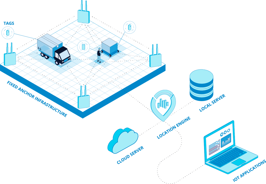
The specific ways real-time location systems operate can vary greatly from system to system, but all RTLS leverage a network of connected hardware and software components that track the location of people and objects within a defined area. To enable indoor positioning, real-time location systems primarily rely on RF technologies such as UWB, Bluetooth, Wi-Fi and chirp that enable wireless communication between a group of transmitting, receiving, or dual-purpose transceiving devices to determine the location of the targeted object. The transmitting device, such as a RF tracking tag or smartphone will send out data encoded RF transmissions, or location “blinks”, at a continuous interval. RTLS receivers (anchors or readers) deployed in fixed positions, such as mounted on walls and within the communication range will receive and read the received signals from the transmitting device. The location data, and in certain applications, accompanying IoT data (temperature, battery, etc.) received by the anchors, is then forwarded to location engine software to calculate the device’s position.

In different RTLS technologiesthe technique used to determine location can differ. Some use distance-based calculations such as time difference of arrival, which tends to deliver more accurate results than Received Signal Strength Indicator (RSSI) among other positioning methods. Enterprise-grade RTLS can include thousands of tracked assets, so a location engine will process this information concurrently for real-time location tracking of numerous targets at the same time. Derived location data can then be used to display the location of tracked items on a map or integrated into various enterprise applications to enable a multitude of location-aware use cases.

Some real-time location systems rely on fixed transmitting devices, such as Bluetooth beacons, which broadcast signals at regular intervals that can be detected by other BLE-enabled devices like smartphones. Location data from the beacons are then collected by those BLE-enabled devices and forwarded to the indoor positioning application to determine the device’s position and trigger specific actions.

In addition to real-time location tracking applications, RTLS components can also enable ranging applications in which communication between two devices, such as two transceiver tags that can be used to determine the relative distance between them, enabling proximity-based applications.

Initially limited to use in government and military applications, the term RTLS was first introduced to the mainstream at ID EXPO in 1998. The concept was presented there to define what emerging location technologies were beginning to become commercially viable and went beyond existing solutions to not only identify active RFID tags, but also visualize their location on a computer. In the 1990s the first commercial deployments of RTLS were activated within three healthcare facilities across the United States. Since then, the category of RTLS has expanded significantly to include new types of RF technologies and drastically improved hardware and software tools.
Did you know icon

Did You Know?

What Components are in a RTLS?

The components used in each individual RTLS, as well as the RF standards and characteristics of those components can vary. Factors such as performance requirements, like accuracy, latency, range, throughput, as well as the complexity of a deployment and desired use cases dictates what type of RTLS components and specific RF technology will best address your needs. However, most location-tracking solutions share these core components – anchors, tags/transmitting devices and a location engine. In addition to those core components there are also modular RTLS components that can be integrated into IoT devices and applications to enable customized RTLS-enabled devices and solutions that meet the needs of specialized use cases and unique end-user requirements.

Anchors

RTLS anchors are readers that deploy in fixed positions to detect and locate signals from transmitting RTLS tags and devices. To accurately determine a tag’s real-time location, each anchor within its communication range will read and often timestamp the received signals, and then exchange this information with the location engine to calculate the tag’s position. In addition to being able to receive communication, certain RTLS anchors can also transmit data to other devices, enabling you to do things like wireless configuration, firmware flashing, and sending data to a tag to manipulate actuators like LEDs or even machines, allowing for more versatile applications.

Tags, Badges, Beacons...

RTLS tags are wireless devices that are equipped to people, assets, equipment, inventory or mobile objects to help determine their location. RTLS tags send data encoded signals at continuous intervals to RTLS readers that then forward this information to the location engine to determine its position. Tags come in all shapes and sizes, such as in form factors like asset tags, beacons, ID badges and more. Certain tags come equipped with additional embedded sensors and long-lasting internal batteries that allow for more flexible applications.

Location Engine (Software)

A location engine is the RTLS software that processes the received location and IoT data from the RTLS hardware. Different location engines leverage different techniques to calculate the position of a tracked person or objects, delivering actionable intelligence that can be integrated into IoT applications and systems like Enterprise Resource Planning (ERP) and Manufacturing Execution Systems (MES).

RTLS Modules

RTLS modules are pre-built transceivers that can be integrated into custom RTLS anchors, tags and connected devices. This helps organizations reduce development complexity and the time to solution required in building their own tailored RTLS-enabled devices. For example, an organization can easily integrate a module into their own proprietary tag design, activating real-time location tracking capabilities with hardware that meets their unique needs, functional and compliance requirements.

RTLS Transceiver Chips

RTLS transceiver chips are essentially the brain of an RTLS-enabled device. Inside RTLS hardware they power the wireless communication that makes real-time locationing possible. The chips serve as the starting point for development of custom RTLS devices. From them, organizations can design their own tailored RTLS-enabled device, such as a location tracking tag, allowing them to develop and build RTLS hardware with complete flexibility and control to create proprietary devices that meet their exact needs, functional and compliance requirements.

IoT Sensors

Smart IoT sensors can be added into RTLS devices and applications to extend RTLS-enabled solutions even further. These sensors deliver additional IoT data that when paired with the derived location data, enriches the intelligence a deployed RTLS uncovers. This includes sensors built directly into RTLS devices, such as 3D accelerometers, temperature sensors, or battery readers in a tracking tag, as well as auxiliary IoT sensors that monitor conditions such as CO2 concentration, temperature, humidity, sound and more.

How Accurate are Real-Time Location Systems?

The accuracy of real-time location systems differ greatly depending on the underlying RF technology and positioning techniques each individual system uses. For applications that require a high degree of precision, a standard like UWB can deliver high location accuracy, +/- 40 cm, through time-of-arrival-based position calculations.

Other technologies that also leverage distance-based position calculations, such as chirp (CSS) can deliver high accuracy between 1-2 meters. UWB and chirp also perform well against RF interference to help ensure accurate results, while other technologies are more vulnerable to these impacts, degrading positioning results. Other traditional positioning technologies such as Wi-Fi and Bluetooth, generally deliver less accurate results between 1-10 meters. This is because most Wi-Fi/Bluetooth-enabled applications rely on Received Signal Strength Indicator (RSSI)-based multilateration, which is less precise than technologies like UWB. In certain applications, precision isn’t a requirement and meter-level accuracy is sufficient. However, new advances in Wi-Fi and Bluetooth technologies are beginning to allow for more precise locationing by implementing time-of-flight (ToF) and angle of arrival (AoA) calculations into their architecture.

The level of accuracy required for a RTLS varies based on individual customers’ needs and desired use cases – some users require high accuracy to instantly pinpoint a piece of critical equipment in a large industrial environment, while others may only need to know the general location of an asset. Accuracy requirements can also be determined based on the number of deployed RTLS reference points.

What is the Range of a Real-Time Location System?

The range of real-time location systems greatly differ depending on the underlying RF technology and type of deployments. Chirp and Wi-Fi-based systems both operate at 2.4 GHz and can deliver long-range accessibility over values of 300 meters. Chirp excels in this regard, as it enables long-range applications, with less required anchors, and functions both in and outdoors with no spectrum license required.

Other technologies like UWB and BLE are much more limited in the range they can provide. The range required for a RTLS also strongly varies based on the deployment environment and individual customers’ needs and desired use cases. Some users require a high degree of range to track assets like containers, pallets, equipment, or personnel across large facilities, between indoor and outdoor areas, or in hard-to-reach places likes mines, while others may be more concerned with ensuring a high degree of accuracy within a more confined area like the exact location of a part as it moves through an assembly line.

RTLS Technologies

Ultra-Wideband

UWB is a cutting-edge RF technology that delivers precise location with positional accuracy of UWB-tagged objects down to the centimeter-level. It can transmit very high data rates over short ranges, and pinpoint exact location in real-time. It also consumes very little power, allowing for affordable and efficient hardware options, such as tracking tags with coin cell batteries that can operate for multiple years without being recharged or replaced. The reason UWB positioning is so precise is due to its distance-based measurement that calculates location based on how long it takes for pulses of radio to travel from one device to another. While this only works over shorter ranges, the location of UWB signals can be determined with an accuracy of less than 50 centimeters (with optimal conditions and deployment), and extremely low latency.

Chirp Spread Spectrum (CSS)

Chirp Spread Spectrum, also referred to as chirp, is a unique RF technology, that offers distinct advantages like long-range positioning, indoor to outdoor support and low power requirements. It’s powerful combination of long-range accessibility, high 1-2 m accuracy, and performance reliability make it one of the most versatile RTLS technologies. It especially excels in industrial-grade deployments, and requires less infrastructure than other technologies for great ROI. Inpixon is the leader in CSS RTLS technology, offering chirp-enabled RTLS solutions including flexible, long-range location tracking tags, anchors and a proprietary location chip, Inpixon nanoLOC, which serves as the foundation of many chirp technology locationing solutions worldwide.

Wi-Fi

Wi-Fi’s vast presence and accessibility makes it a very important standard for RTLS applications. It can be leveraged in many location-based use cases and offers options to easily get started with indoor positioning through existing Wi-Fi access points and infrastructures. Wi-Fi indoor positioning solutions use existing Wi-Fi access points or Wi-Fi enabled sensors, to detect and locate transmitting Wi-Fi devices, such as smartphones and tracking tags throughout indoor spaces. Location data collected by sensors or access points, or sent from APs to client devices, is ingested by various locationing applications and translated into insights that power multiple location-aware use cases. Wi-Fi-based positioning systems can use different methods to determine the location of devices. Most rely on Received Signal Strength Indicator (RSSI) based techniques. However, some applications can leverage more advanced Wi-Fi positioning methods.

Bluetooth Low Energy

BLE has unique characteristics that have made it one of the most popular RF technologies for RTLS. BLE has a large presence in wireless devices, an extensive set of low-power, low-cost, and easy to implement hardware options, and the flexibility to be used in many location-based applications. BLE indoor positioning solutions use either BLE-enabled sensors or beacons to detect and locate transmitting Bluetooth devices, such as smartphones or tracking tags throughout indoor spaces. Location data collected by the sensors or sent from beacons to mobile devices is then ingested by various locationing applications and translated into insights that power multiple location-aware use cases.

RFID

There are two main categories of RFID technology – passive RFID and active RFID. Passive RFID relies on battery-less tags that receive signals from RFID readers which then power the tag if within the communication range. From this, the location of the tag can be determined, although due to interference with physical obstructions – passive RFID typically only yields short-range positioning. Passive RFID is a low-cost option suitable in deployments where not much more than identification is required. Active RFID – includes tags with an integrated battery and receivers that operate similar to how passive RFID does. They are usually more expensive than their counterpart but offer a longer range. However, they are still vulnerable to interference by physical obstructions just like passive RFID.

Infrared (IR)

IR isn’t a widely used RTLS technology, but it can be leveraged for locationing in addition to or without other RF standards. Infrared is the same technology leveraged in TV remotes. Just like a remote, an infrared-based tag can send out an optical signal to a receiving device and use this to determine its location. Infrared requires line of sight between a transmitter and receiver to function and is limited to only providing room-level accuracy. While IR tags are typically very low cost, deployments require costly infrastructure to track the tags, which most organizations likely won’t already have.

Ultrasound

Ultrasound is a sonic alternative to RF and optical locationing technologies. Deployments use ultrasound waves which are capable of determining the precise location of objects but encounter physical barriers, such as walls, which limit ultrasound’s effectiveness to room-level accuracy.

RF Technology Comparison

Accuracy
Range
Power Consumption
Protection Against Interference
Cost

UWB
Accuracy +/- 40 cm*
Range 0-50 m* (up to 200 m)
Power Consumption Low
Protection Against Interference Strong
Cost $$
Chirp
Accuracy 1-2 m*
Range 10-500 m* (up to 1000 m)
Power Consumption Very low
Protection Against Interference Strong
Cost $
Bluetooth
Accuracy < 5 m*
Range 0-25 m* (up to 100 m)
Power Consumption Very low
Protection Against Interference Weak
Cost $$
Wi-Fi
Accuracy < 10 m*
Range 0-50 m* (up to 500 m)
Power Consumption Moderate
Protection Against Interference Weak
Cost $$$ (low $ with Wi-Fi access points)
Passive RFID
Accuracy 1 m*
Range 0.5-3 m*
Power Consumption None (when passive RFID)
Protection Against Interference High
Cost $
Infrared (IR)
Accuracy 0.5-3 m*
Range 1-5 m*
Power Consumption Low
Protection Against Interference Weak
Cost $$
Ultrasound
Accuracy 0.3 m*
Range 10-75 m*
Power Consumption Low
Protection Against Interference Weak
Cost $$$

* With optimal conditions and deployment

Indoor Positioning Techniques

Diagram illustrating the Time Difference of Arrival principal.
Time-Difference of Arrival

TDoA utilizes UWB or Chirp anchors that are deployed in a fixed position throughout an indoor space. These anchors then detect and locate a transmitting device, such as a tracking tag. To work properly, the fixed anchors need to be accurately synchronized to run on the same clock. The tag, or other device, will transmit signals in regular intervals. These signals will be received by any anchors in the communication range and time-stamped by the anchors. All the time-stamped data is then sent to the central IPS or RTLS.

The location engine will analyze each anchor’s data and the differences in arrival times to each anchor and use multilateration to calculate the tag’s coordinates. Those coordinates can be used to visualize the location of the device on an indoor map of your space or leveraged for other uses depending on the specific application.

Diagram illustrating Two-Way Ranging principle via Time of Flight.
Two Way Ranging (TWR)

While in TDoA multiple fixed anchors work together to determine the location of a mobile object, Two-Way Ranging primarily uses two-way communication between two devices, such as smartphones or vehicle tags, to sense the distance between them. This means that an autonomous collision awareness system can be created without any additional infrastructure. With TWR, when a device is in close proximity to another, the two devices will start ranging with each other to determine their distance, even as they communicate. The time it takes a signal to travel between them is then multiplied by the speed of light and used to determine their relative positions, frequently, to enable location-aware communication.

Diagram illustrating the Angle of Arrival principal.
Angle of Arrival (AoA)

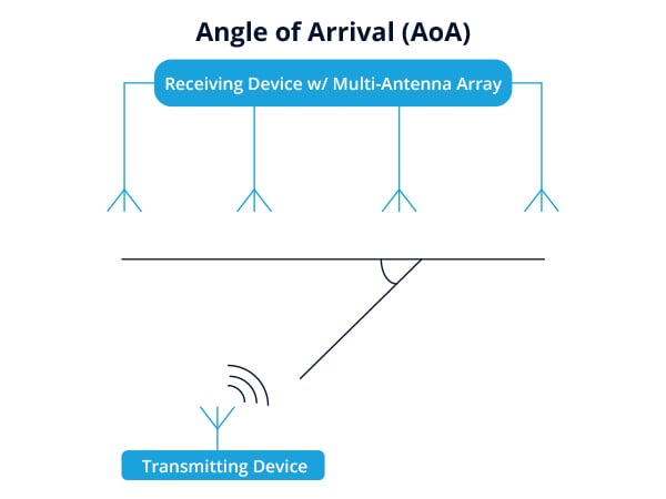
AoA is an advanced positioning method which can deliver with enhanced accuracy compared to more traditional techniques like fingerprinting and RSSI. This is possible due to Multiple Input Multiple Output (MIMO) interfaces. To be able to find direction, a mobile asset, such as a tag or beacon with a single antenna, transmits to a fixed RTLS sensor with a multi-antenna array. The phase shift of the multiple antennas, as a result of receiving the signal, is measured and calculated to determine the angle of the transmitting mobile device and create an area of certainty of the object to be located.
One advantage of an AoA approach is that it reduces the number of necessary reference points. Instead of a minimum of three sensors as required for any multilateration approach, you only need two to create an unambiguous determination of position. Additional reference points add to the accuracy and reliability of the calculated positions. While indoor positioning via AoA is more accurate than signal strength approaches, solutions that leverage this technique are only just entering the market.

RSSI RTLS Diagram
Received Signal Strength Indicator (RSSI)

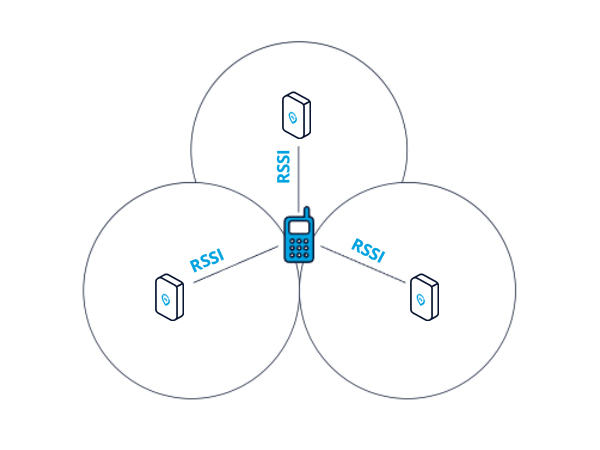
In RSSI-based applications, multiple existing RTLS sensors deployed in a fixed position will detect transmitting devices and the received signal strength of the signal from the device. This location data collected by the sensors is sent to the location engine. The location engine analyzes the data and uses multilateration algorithms to estimate the location of transmitting devices. Alternatively, the signal strength of nearby sensors relative to a wireless device can be used to determine the device’s location.
Using an RSSI-based method with multilateration is the most easily activated and low-cost option for indoor positioning. However, it doesn't deliver a high degree of positional accuracy because it is subject to signal attenuation, absorption, reflection and interference.

RTLS Key Benefits

Enhance Safety & Prevent Costly Incidents

Create real-time visibility to help identify, prevent and respond to threats to worker safety. Improve compliance efforts and power use cases like collision avoidance, evacuations, worker search and rescue, contact tracing and more.

Improve Efficiency & Streamline Workflows

Leverage location to help boost productivity and connect siloed processes. Instantly track assets and personnel, identify potential bottlenecks, poor resource utilization and more.

Drive Business Results

Harness location data and context to make smarter more informed decisions, improve resource allocation, reduce costs, boost production speed and quality, as well as asset performance and more.

"We’ve evaluated numerous location technologies and chose Inpixon due to their ability to deliver real-time location of personnel, vehicles and assets, even over relatively long ranges and in RF-challenged environments."

Eric Baker | Chief Innovation Officer, Schauenburg Systems

Applications and Use Cases for RTLS

AWARD WINNER

IoT Evolution Asset Tracking Award

2022-IoT-Evolution-Asset-Tracking-Award

Inpixon RTLS has been recognized with a 2022 IoT Evolution Asset Tracking Award, which highlights excellence and innovation in IoT solutions that enable asset tracking to optimize operations.

Learn More

Inpixon RTLS Solutions

Inpixon is proud to provide the knowledge, hardware and software you need.
Create a functioning RTLS to gain accurate and actionable data to make your indoor spaces more productive, cost-effective and safe.

Ready to talk RTLS?
Contact us!